Zombie Safe Zone Maps
/zombie-safe-zone-maps-13838.jpg "Zombie Safe Zone Maps")
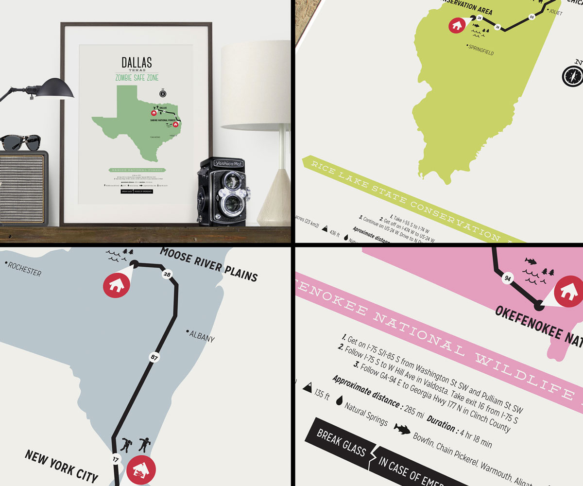
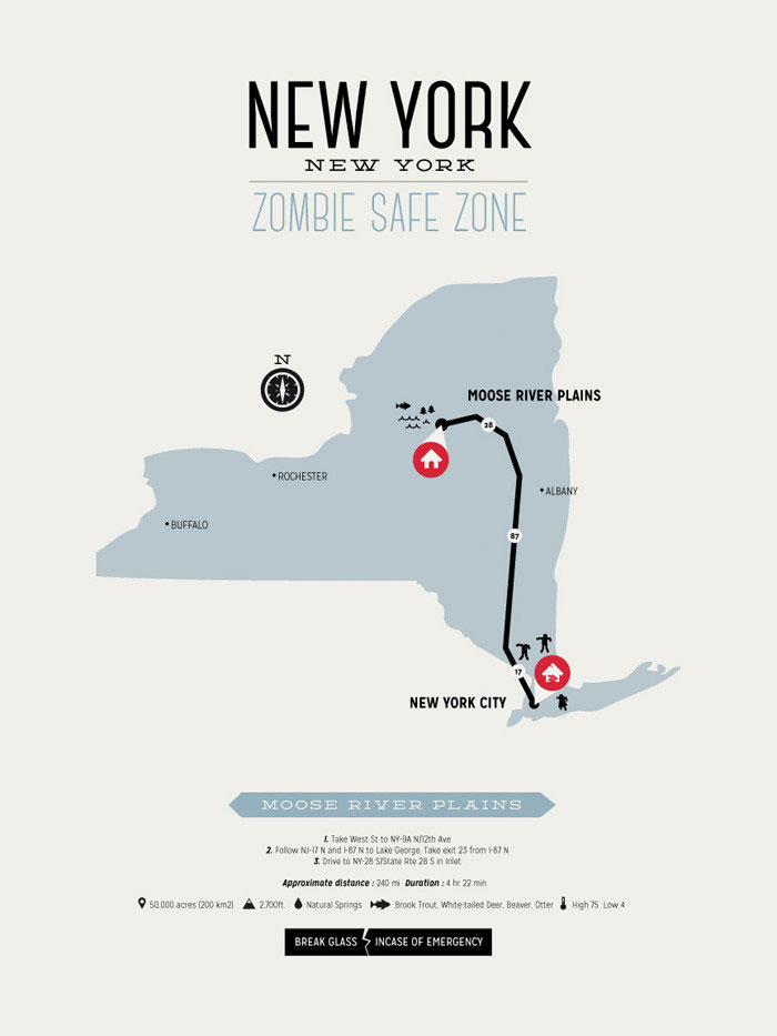


When they strike, the zombies will go for the masses. So those of us living in major US cities have 2 choices: be afraid; or be prepared. Since Ryan McArthur of Design Different, unlike the evening news, isn't into fear mongering he's created this series of Zombie Safe Zone Maps to help us get the F out of their warpath as soon as the Zompocalypse begins.
McArthur notes that to survive a zombie invasion "you need to find a safe zone, somewhere where there's a natural abundance of water, fish and forestry." New York City. Atlanta. Dallas. Chicago. Suddenly terrible (or even more terrible, depending on your perspective) places to be. Zombie Safe Zone Maps mark the fastest route to the nearest and safest place you can go when the time comes to escape your city and the walking dead that have descended upon it. McArthur's posters detail Safe Zones in states with the most popular cities prone to a zombie outbreak, a series of 9 in all. Each map establishes a From and To point, plus the most expedient path connecting them. At the bottom of the prints you'll also find explicit directions, distance, travel time, and additional information about the Safe Zone, such as water type and food resources.
If your city isn't included in the existing Design Different collection, McArthur will also make you a custom Zombie Safe Zone Map.
Maps are available in a variety of sizes, ranging from 8" x 10" to 13" x 19". They also come in the buyer's choice of 9 different colors. All prints include a 1/4" white border and are printed on heavy weight 240 gsm archival matte paper.
Zombe Safe Zone Maps are a top Dude Gift for a Geek pick.
/snow-melting-stair-mat-62406.jpg?mode=crop "Snow-Melting Stair Mat")
Snow-Melting Stair Mat
What?! A snow-melting stair mat? But, but, why? Everyone knows the best part of piled-up Mother Nature dandruff is watching people wipe out trying to navigate through it! I do feel bad for the AARP-aged ones when they...
/magicalbutter-cannabis-cooker-62400.jpg?mode=crop "MagicalButter Cannabis Cooker")
MagicalButter Cannabis Cooker
Easily make medicinal butter, oils, tinctures, lotions, and sauces. Hear that? MagicalButter is so named for its power to convert healing herbs into healing herb culinary creations. So start coughing and breaking into...
/disturbed-friends-the-worst-62430.jpg?mode=crop "Disturbed Friends - The Worst Game Ever Made")
Disturbed Friends - The Worst Game Ever Made
Consumer drones? Wearables? Self-driving cars (and -walking shoes)? Nah. I think politically incorrect card-based games that at some point make every person playing them feel extremely uncomfortable or self-conscious...
/heng-balance-magnetic-switch-62549.jpg?mode=crop "Balancing Magnetic Switch Lamp")
Balancing Magnetic Switch Lamp
Newton's Cradle meets abacus meets the first day of creation in these balance lamps with magnetic switches. Li Zanwen created the desk lamp design with a pair of magnetic wooden balls on strings at the center that attract...
/earwax-candle-kit-56889.jpg?mode=crop "Earwax Candle Kit")
Earwax Candle Kit
Here comes the Earwax Candle Kit just when you thought you couldn't find the perfect gift for your mom. I don't know about yours but I know my mama loves candles, and also hates waste, and based on the number of used...
/night-vision-goggles-62570.jpg?mode=crop "Night Vision Goggles")
Night Vision Goggles
These hands-free night vision goggles mean surveillance, after-dark expeditions, and finding the perfect bush to pee on in the middle of the night aren't just possible, they're on like Donkey Kong!...
/spyfinder-pro-hidden-camera-62610.jpg?mode=crop "Hidden Camera Detector")
Hidden Camera Detector
Hidden cameras watching me in the dressing room? In my vacation rental? In the office? ... Well, I figured they're watching me in the office. Listen, I'm not trying to stir up any paranoia here, but this hidden camera...
/jumbl-puzzle-board-wooden-46537.jpg?mode=crop "Jumbl Puzzle Board Wooden Jigsaw Puzzle Table")
Jumbl Puzzle Board Wooden Jigsaw Puzzle Table
What, you can't finish that 1,500-piece jigsaw puzzle of a color gradient in one sitting? Sigh. Why'd you open it then? Now it's going to be cluttering up the dining room table for the next 3 weeks! Shoulda bought a Jumbl...
/headache-migraine-relief-cap-62512.jpg?mode=crop "Headache & Migraine Relief Cap")
Headache & Migraine Relief Cap
Headache? Migraine? Just want to bury your head in the freezer or a bucket of ice? How about a striking purple hat filled with cooling, soothing, pain-easing frozen gel instead?...
/plufl-the-dog-bed-for-humans-62576.jpg?mode=crop "Dog Bed for Humans")
Dog Bed for Humans
Welp, we've got dog food for humans, so why not dog beds for humans? Thank you Soylent, and now, YAEM...
/screaming-aztec-death-whistle-62534.jpg?mode=crop "Screaming Aztec Death Whistle")
Screaming Aztec Death Whistle
How have I never heard of a Screaming Aztec Death Whistle? In all my efforts to exact revenge on my ex-girlfriend, Karen, in all my attempts to prank my friend Cornelius, in all my ploys to convince my mother-in-law our...
/rechargeable-heated-slippers-62388.jpg?mode=crop "Rechargeable Heated Slippers")
Rechargeable Heated Slippers
Rechargeable Heated Slippers may be a boring, uninspired idea for a holiday gift, but they're not a bad idea. Think of all the people with cold feet out there. And all the people who have moderately warm feet inside...